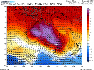
 It seems we are in a lull of storm activity and set to enter a very warm to hot extended episode over southeastern Australia. Now this makes things rather interesting as La Nina heat waves produce very hot and relatively humid conditions and often can be followed by heavy rainfall events.
Regards,
Jimmy Deguara

Hi Jimmy, i’ve been thinking about that as well and about what a typical La Nina breakdown looks like in regards to thunderstorm activity. If it leaves us with higher than average humidity levels we could be in for a stormy march/april period this year when more signifcant upper troughs start returning?
Jeff
Absolutely Jeff. However, sometimes you don’t have to wait that long. Consider the last major La Nina event at this time of the year:
1990 March 7th March Major hailstorm and likely supercell hits the Hawkesbury region including Windsor
March 18th 1990 – Supercell hits the southwestern Suburbs to Auburn / Libcombe to Dee Why corridor. Major damage into the hundred of millions of dollars of damage.
1991 January 21st 1991 – Major hailstorms and severe microbursts in the northern suburbs from Kelliyveille through to Turramurra and St Ives and Kuringai National Park encountered extreme microbursts. The cost of this disaster ran into the hundreds of millions of dollars making it the costliest disaster before the 1999 Sydney hailstorm. Earlier the same day as part of the initial system, an extraordinary hailstorm with potentially extremely giant hail demolishes the Oakdale area.
1992 Major hailstorm in the Toongabbie to Wentworthville area February 12th 1992. Unconfirmed reports but reports of very large to giant hail in this event!
How is that for a list!
Jimmy Deguara
Bring it on!!! I’m getting really excited after last years second season ended up being a complete storm drought for us and i’m itching to capture some high contrast supercell panoramas.
Jeff.
Some storms today along the ranges between Cooma and Bombala and into Victoria. The mega cap didn’t stop initiation along the seabreeze front and they had a severe storm warning for flash flooding and large hail. There might have been some small hail but more than likely the biggest danger was micro bursts from high bases.
Tomorrow it looks set to fire along the central coast tomorrow and there is already popcorn convection this afternoon in western Sydney.
Jeff.
It’s quite humid today in the Sydney basin. There is not a lot of CAPE or Lifted Index forecast for Sydney today but with the current obs at Penrith reading 33/22 there is ample energy for strong convection and those plot should be taken with a grain of salt. The latest balloon from Sydney revealed an 850mb temp of 20 degrees so there is a cap in place but there is a lot more energy than is forecast below it, there is also drying off of the dew point above 700mb and an upper trough is forecast to pass over this afternoon. Looks like we will see some higher based hailstorms today?
Jeff.
On the 3rd of January storms developed in the southeast along a convergence boundary.These were mostly located in a line between the Victorian border and Araluan. Its quite possible some of these were locally severe with flash flooding being the major risk.
Later that night a few weak and high based storms developed further north near Nowra and Jervis Bay. These delivered some fairly nice lightning as seen below…
Both shots taken on the eastern outskirts of Nowra..Bolts were around 2-4kms away.
Following this another storm just south of Jervis Bay put on a nice stacatto display for roughly 10minutes.
I missed tonights storms in Sydney due to work (again), however there have been reports of a tornado at Lake Burrendong , south of Wellington. Here
See : 256km Radar Loop for Sydney (Terrey Hills), 03:00 05/01/2012 to 07:00 05/01/2012 UTC
is the radar loop for the storm that produced it – seemed to be a relatively long lived supercell that started west of Cumnock, and tracked E/NE up to Goolma before dying in the rainband. Hopefully there are photos somewhere.
I couldn’t get out yesterday, I wanted to chase but I had to stay at home while the wife worked. I would’ve headed out to the central tablelands as well, oh well. I got some shots of the lightning from the backyard yesterday but couldn’t get to a better vantage point.
Jeff.