http://www.extremestorms.com.au/rain-storm-potential-eastern-australia-20-to-25-november-2023/
Over the past 6 days, vast areas of southern and eastern Australia affecting Queensland, New South Wales, Victoria, eastern South Australia and the Australian Capital Territory have experienced a multiday rain, storm event and even some flooding.
Very few areas have missed out and almost all localities and weather stations have experienced something from this event.
Further still, the event is expected to continue into the new week with a second burst of rain and storms especially during Tuesday and Wednesday.
Most of the thunderstorm activity has occurred across the inland regions and certainly for coastal New South Wales around Sydney and the Illawarra, light rainfall has been more of a feature rather than the short sharp downpours typically associated with thunderstorms.
The system commenced Sunday afternoon across the inland northern areas of New South Wales and inland southern areas of Queensland. Some of the falls from the initial event (Rain and thunderstorms) were substantial.

1 - To 9 am Monday morning (The heaviest falls were)
Queensland
- Cardiff - 118 mm.
- Jericho - 102 mm.
- St George - 76 mm.
All located within the southern inland Queensland region.
Further, another small area just north of Bundaberg experienced 50 mm falls.
New South Wales
- Goondiwindi region - 50 to 100 mm.
- Ripple Downs - 100.
- Boomi Offtake - 84 mm.
- Lundavra TM - 75 mm.
- Moree region - 25 mm to 49 mm.
This was the region that was falling back into drought following an extended dry period. Such rainfall would have been beneficial to the region. This event did not reach coastal areas.
2 - To 9 am Tuesday morning (The heaviest falls were)
During Monday afternoon, it was the Australian Capital Territory’s and the surrounding regions turn to receive the rain and storm activity with some significant totals occurring. These include:
- Canberra (Curtin) - 41 mm.
- Corin Dam - 41 mm.
- Lake Burley Griffin - 36 mm.
- Muttama (NW of Canberra) - 54 mm.
A small area on the New South Wales and Queensland border inland from the coast around Amiens Knob Alert experienced falls of between 50 mm to 64 mm.
3 - To 9 am Wednesday morning (The heaviest falls were)
A significant thunderstorm impacted the town of Deniliquin (Western Riverina of New South Wales) that brought damaging wind gusts to 93 km/h at around 3.30 pm to 3.33 pm. This storm brought 4.6 mm in 3 minutes during the same time with a total of 19.2 mm falling.

The focus of the thunderstorm activity shifted to south west New South Wales but across the western Riverina with Deniliquin being hardest hit area.
In addition, strong rainfall totals from a separate cluster of showers / rain / storms brought 34 mm at Bathurst.
Further, rainfall on the New South Wales north coast reached:
- Mt George - 36 mm.
- Bretti - 25 mm.
A small locality around Keeva north west of Tamworth had 112 mm but this was isolated to one locality.
Queensland
An area around Miles experienced significant storm activity including:
- Stillers Road Alert - 118 mm.
- Pinelands Alert - 80 mm.
- Clovelly Alert - 74 mm.
The big events within the area are causing localized flooding of low lying areas.
4 - To 9 am Thursday morning (The heaviest falls were)
The area around Bathurst and Orange (Central Tablelands) were hardest hit and it is known that local flooding occurred in Orange where 50 mm fell from a single event.
- Oberon - 61 mm.
- North Orange - 38 mm.
On the New South Wales North Coast, isolated falls of 50 to 62 mm fell around Bellingen and Thora.
5 - To 9 am Friday morning (The heaviest falls were)
More substantial rainfall occurred across the northern inland regions of New South Wales and southern Queensland with more thunderstorm activity. This includes:
New South Wales
- Quambone Station - 57 mm.
- Lightning Ridge - 37 mm.
- Walget region - 25 to 49 mm.
Queensland
- Hebel - 77 mm.
- Narran River (Just north of the New South Wales state border) - 52 mm.
Incredibly, intense rain and storm activity impacted far western Victoria across parts of the Wimmera resulting in the following occurring:
- Pigick Comparison - 71 mm.
- Hillview Nypo - 55 mm.
- Gerog Gerog - 51 mm.
- Region around Dimboola and Nhill - 25 to 49 mm.
This is unusual as the region usually does not see these events occur due to location. This does show how widespread the system became. This event crossed into parts of eastern South Australia.

6 - To 9 am Saturday morning (The heaviest falls were)
Friday evening, light rain reached Sydney but totals were generally in the range of 5 to 12 mm.
There were widespread falls of 10 mm to 24 mm across Victoria, New South Wales and even into Northern Tasmania with a few totals reaching 40 mm. Generally, this event was widespread rather than hit and miss thunderstorms of previous days.
Saturday afternoon
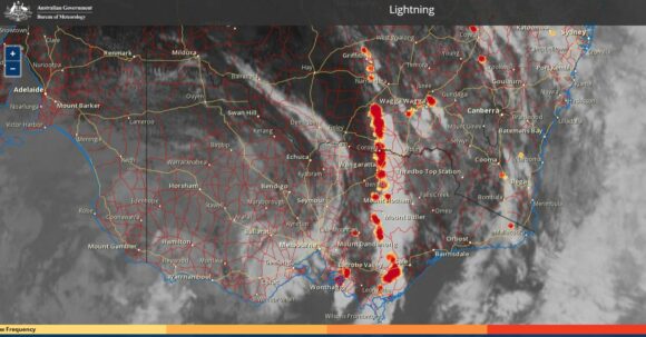
With much of the east coast under low cloud and shower activity, some heating did occur across the inland and it is known that thunderstorm activity increased again. Thunderstorms occurred:
- Southern Victoria around the towns of Sale and Wonthaggi.
- South west New South Wales around Wagga Wagga where a single thunderstorm dropped almost 10 mm of rain including 5.6 mm in 4 minutes including wind gusts to 54 km/h at 1.59 pm.
- Rutherglen where 18.2 mm fell in 26 minutes between 1.34 pm and 2 pm.
- North west New South Wales around Cobar and Brewarrina plus areas further north and west where there are few population centres.
The storms generally did not track further east than Yass and went into decay due to unfavourable conditions further east.

This event will continue with a second system developing between Monday and Wednesday before clearing. Thus, it can be expected that more of the same will occur early to mid week.
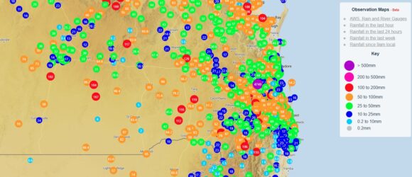
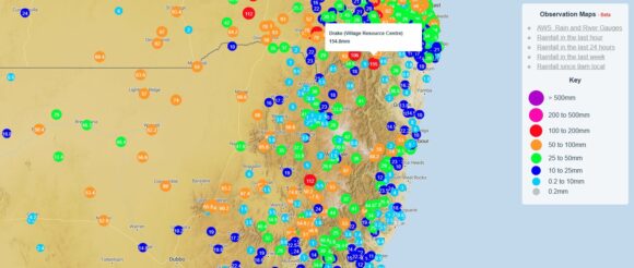
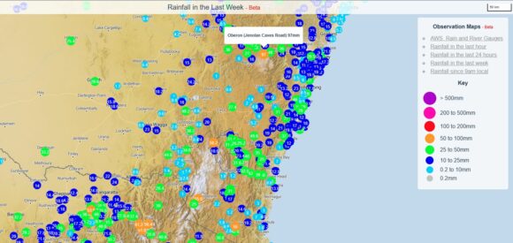
I have attached the weekly cumulative rainfall plots for much of Eastern Australia. In addition, the feature image presented is from a previous storm chase but not too dissimilar to what has been occurring across inland regions of southern and eastern Australia.
