Following the recent heat outbreak which concluded on Sunday 19 March across eastern areas of New South Wales and Tuesday 21 March across the northern inland areas of the state, a relatively significant rain and storm event outbreak commenced which for some areas, ended a developing dry spell.
Initially, the rain and storm events were hit and miss and thus any heavy falls associated with the system were isolated in nature.
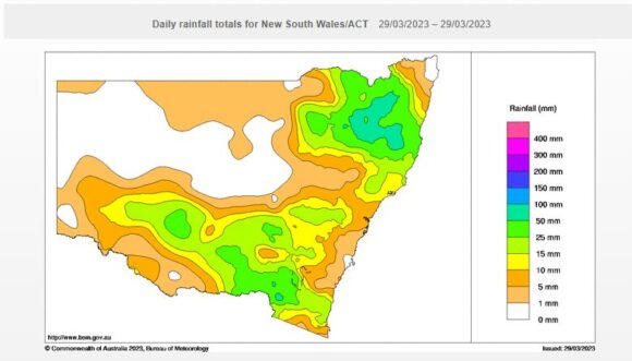
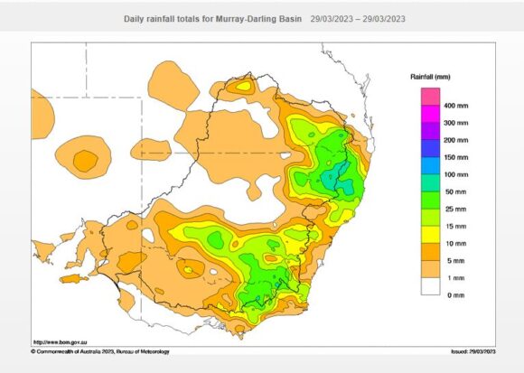
However, a more significant event occurred on Tuesday and Wednesday the 28 and the 29 March which saw some strong rainfall totals occur. While no major flooding occurred, this was significant as rainfall totals topped 50 to 99 mm for some isolated areas.
Initially, any heavy falls were isolated in nature as shown:
Afternoon 22 March 2023
- Orange - 52 mm.
- Orange Agriculture Institute - 54 mm (To 9 am 23 March).
Afternoon 23 March 2023
A weak afternoon storm passed over Sydney’s west that was structureless but only brought very light rainfall totals of around 5 mm across Blacktown. This was the only time during the month when any form of lightning was observed.
Friday 24 March 2023
- Murrurundi - 31.3 mm.
- Orange Agriculture Institute - 27.8 mm.
Saturday 25 March 2023
An intense rainstorm swept over Goulburn mid to late morning. At 10.44 am, only 1 mm had been recorded but by 11 am (16 minutes later), the rain gauge had recorded 27.4 mm (26.4 mm in 16 minutes). The final tally was 33 mm from the entire event.
At Gunnedah, moderate to heavy rainfall impacted the town where 42.6 mm fell between 9 am and 1 pm Saturday afternoon for a final tally of 49.2 mm to 9 am Sunday morning.
The town of Gunnedah finished up with 218 mm for the month of March following 3 major rain events during the month resulting in a very wet month.

Tuesday and Wednesday 28 and 29 March 2023
There were two regions of the state that were impacted by substantial rain events with the heaviest totals falling across parts of the Northern Tablelands and strong totals falling across parts of the South West Slopes of the State.
Falls of 50 to 108 mm fell across the Northern Tablelands including:
- Ben Lomond (NNW of Guyra) - 108 mm.
- Uralla - 90 mm.
- Bundarra - 74 mm.
- Macintyre River - 70 mm.
- Stannifer Rubicon - 66 mm.
- Wollomombi - 65 mm.
- Armidale - 62 mm.
The South West Slopes of the state also recorded some strong totals including:
- Long Plain - 67 mm.
- Book Book - 59 mm.
There were also falls of up to 67 mm at Falls Creek in North East Victoria.

Much of the South West Slopes received at least 25 to 50 mm which broke a developing dry spell across some areas.
The water and the land plots are attached showing such rainfall from the recent events.
For Sydney, rainfall was much lighter and well below the above figures across the whole period. It is noted that following this event, night time minimum temperatures dropped sharply as cooler drier air swept through indicating the onset of autumn.
Note: The feature image attached is taken in 2022 Doonside. Such scenes of heavy rain and localised water ponding of low lying areas would have occurred around Gunnedah, Goulburn, Orange and Armidale following the heavy rain events of recent days.

