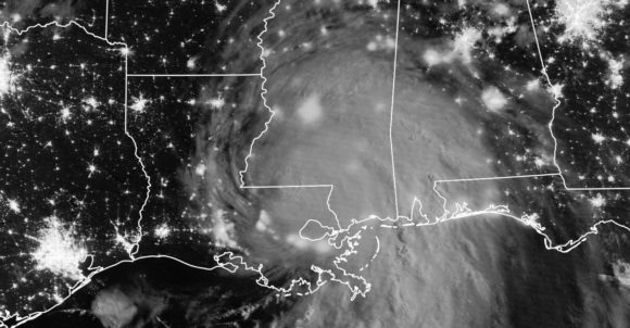
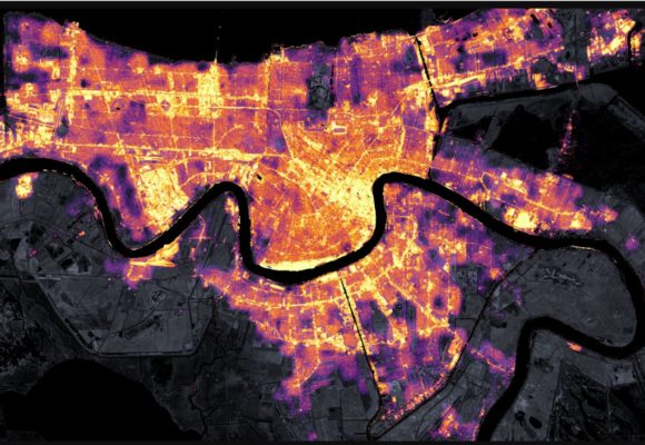
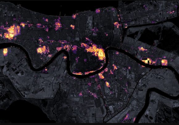
The attached images of New Orleans acquired from NASA and dated 9 August and 31 August 2021 by the Suomi NPP satellite shows the stark impact caused by Hurricane Ida. Prior to the storm, the entire city of New Orleans is visible at night with the city centre, the brightest white generally centre of the image with Lake Pontchartrain to the north and the Mississippi River snaking its way through the centre.

Following the storm, most of New Orleans is without electricity and dark. The storm has caused immense damage and destruction to the infrastructure of the city. The city centre is lit again although most of the suburbs are in the dark.


Some of the lit areas are a result of backup electricity generation from diesel power units.
Instruments - Landsat 8-OLI.
Suomi NPP - VIIRS.
Source - Images acquired from NASA Earth Observatory (9 and 31 August 2021).
The storm has left at least 985,000 customers without power for days, weeks and even months. It appears another 33,000 customers are currently without power in nearby Mississippi.
Coupled with flooding, the situation is dire and the recovery will be difficult from such a storm. It is difficult to obtain readings from weather station as either such units have failed, were destroyed or stopped recording due to power loss as the storm passed over.
A weather station at Galliano (South Lafourche Airport) recorded a wind gust to 98 mp/h at 1.15 pm and another powerful gust of 95 mp/h at 3.55 pm (Converted to gusts of 157.6 km/h and 153 km/h but the station stopped recording thereafter. (Source NWS airport weather station Galliano).
There is reasonable evidence of a wind gust to 172 mp/h (Converted to 276.7 km/h) on a ship with an onboard weather station at Port Fourchon 100 km south of New Orleans. This is being reviewed but is credible as it was measured by NOAA Meteorological Officers. If confirmed, then this would be the highest wind gust known or confirmed from the storm.
Other intense wind gusts of 153 mp/h (Converted to 246 km/h) were reported at Lee Ville, 138 mp/h (converted to 222 km/h) at Dulac and 121 mp/h (Converted to 194.6 km/h) at Venie.
(Source NWS).
The storm appears to be the fifth strongest storm to make landfall in the United States and it is noted that landfall occurred 16 years to the day following Hurricane Katrina in 2005.
The storm became so strong so quickly because of the amount of warm water of 30C and 31C available that was situated along and off the coast of Louisiana. Unlike Hurricane Katrina which weakened a little before landfall in 2005, Hurricane Ida strengthened before landfall then slowed down after landfall which compounded the damage.
(Source Associated Press 2021, August 30 Hurricane Ida lashes Louisiana, knocks out New Orleans power)
Rainfall
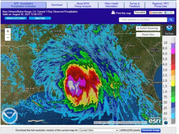
With the loss of so many weather stations, it is difficult to ascertain how much rain fell within the area but a plot produced on the National Weather Service website for rainfall 30/8/2021 identifies likely rainfall for August 30 as being as high as 250 mm around New Orleans and 150 to 200 mm within immediate environs that the day.

Damage assessment
News images are providing detailed accounts of flooding and damage to infrastructure and buildings and it is far too early to ascertain damage costs or recovery times. News articles are reporting six fatalities at the time of writing which is expected to rise.
It is identified that most of the new levy banks constructed after Hurricane Katrina appear to have held up with only minor damage which will make search and rescue easier when compared to what occurred 16 years ago. Even though there is major flooding, it is less than what occurred during Hurricane Katrina.
I have been to New Orleans and remember being in this city on July 4 2002. I took note of the size of some of the levy banks along the Mississippi River and how low this city is when compared to surrounding water bodies. Without any of the levy banks, this city could never be built in this location due to such high flood risk.
Tropical storm
The storm was downgraded to a tropical storm following landfall which then tracked north east causing significant flooding to communities and other cities. The storm has passed over New York causing major flooding impacts in Manhattan and further state of emergencies. The north east United States has seen a wet summer from recent storms and the remnants of IDA has only added to the existing flooding that has occurred.
It is known that flash flooding and flooding has caused more than 40 fatalities.
