
Whilst my wife and I were Indonesia, two weather events that were occurring across separate regions of Australia came to our attention. They were:
- A heatwave and associated bushfires across southern Australia and in particular Victoria which occurred between the 6 and the 12 January.
- The landfall of a tropical cyclone near Townsville Queensland (Category 1 system on the Saffir Simpson Scale and Category 2 on the Australian Tropical Cyclone Intensity Scale of 1989) which was named as Koji during the same period.
Both impacted the Australian continent generally at the same time.
We were watching both events on television in Yogyakarta via “Youtube” and our Indonesian family were shocked to see such weather events unfold across Australia. I had to explain that this can occur during the Australian summers and that weather related natural disasters do occur and can be costly events.
I had to explain that Indonesia does not experience tropical cyclones, heatwaves or catastrophic bushfires. Instead, Indonesia does suffer from major earthquakes and volcanic eruptions which Australia does not experience.
Our Indonesian family learnt that both countries do suffer from flooding associated with major rain events.
The heatwave event of Victoria was the strongest such event since the summer of 2019/2020 and many regions of the state especially north of the Great Dividing Range experienced at least three days where the maximum temperature reached or exceeded 40C.
In addition, the heatwave event spilled into the inland southern region of New South Wales and even impacted the inland suburbs of Sydney generally west of Parramatta.
Further to this, the north west region of New South Wales has been under heatwave conditions since the beginning of the new year. As such, isolated townships including Tibooburra has been experiencing exceptionally high temperatures of between 34C and 43C since January 1 2026 including 8 days where the maximum temperature has exceeded 40C.
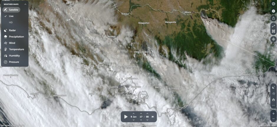
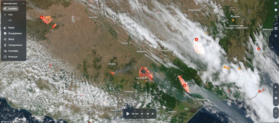
Perhaps the most telling of this heatwave were the catastrophic fires that resulted. Much of Victoria has been dry over the past 2 years and drought conditions have prevailed across large areas of the state. All it took was a hot spell coupled with north west winds and an ignition point to start a catastrophic event. Fires burned around Longwood and east of Seymour (Lower North east Victoria), Walwa (Upper north east Victoria east of Albury / Wodonga including an area that I know quite well), the Great Dividing Range and other areas across Western Victoria.
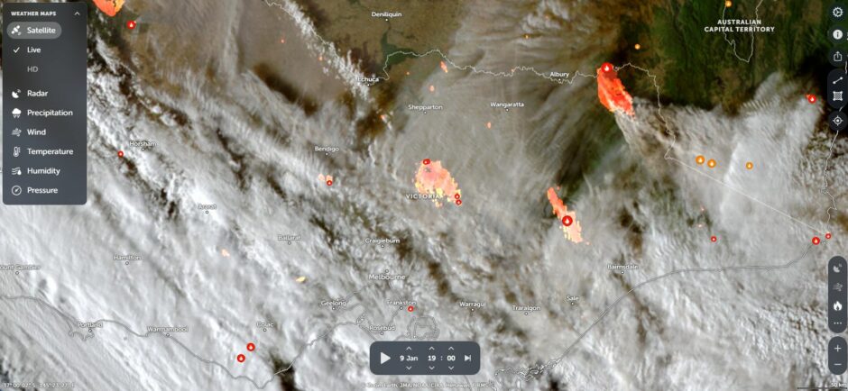
It is understood that approximately 400,000 hectares have been scorched to date and when viewing NASA Zoom Earth Saturday morning 17 January, the larger fires are still burning. The Walwa fire has flared up again in difficult and rugged country.
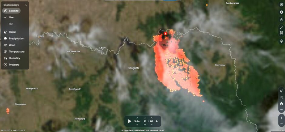
I have attached some images from Zoom Earth to show the fires burning across the state and the true scale of these can clearly be seen.
I am aware of one fatality with at least 350 known structures destroyed although this could be higher as the fires are ongoing at the time of writing.
While some of the heat reached the coastline especially during January 10, much of the heat remained inland away from the coast. A table has been prepared below showing a sample of the maximum temperatures reached during the event.
| Location | January 6 | January 7 | January 8 | January 9 | January 10 |
| Albury Airport | 36C | 41.1C | 43C | 42C | |
| Badgerys Creek (W Sydney) | 38.7C | 42.2C | 42.2C | 42.8C | |
| Balranald | 36.1C | 44.8C | 45C | 44.8C | |
| Bega | 40.3C | 40C | 37.7C | ||
| Bourke | 1 to the 15 January 2026, the minimum temperature recorded was 37.7C with the maximum being 43C. | ||||
| Camden (SW Sydney) | 38.6C | 41.9C | 41.4C | 42.4C | |
| Dubbo | 36.2C | 39.1C | 39.6C | 38.5C | 39.3C |
| Forbes | 40.3C | 41.2C | 40.1C | 42.3C | |
| Griffith | 37.7C | 42.1C | 44.1C | 42.9C | |
| Hay | 38.9C | 44.6C | 45.9C | 44.9C | |
| Ivanhoe | 39.3C | 43.5C | 44.9C | 43.7C | |
| Penrith (W Sydney) | 38.4C | 42.1C | 42.5C | 42.5C | |
| Mildura (NW Victoria - Mallee region) | 38.5C | 44.1C | 45.6C | 45.8C | |
| Swan Hill (NW Victoria - Mallee region) | 38.9C | 43.8C | 46C | 45.8C | |
Our Indonesian family were shocked to learn that daytime temperatures can rise to 46C during summer compared to maximum daytime temperatures of around 30C to 32C for Yogyakarta.
Notes:
1 - A cool change came through during the 10 and the 11 which ended the extreme heat for most areas except for the northwest of the state (NSW) where the heatwave has continued.
2 - Many inland areas including western Sydney experienced 3 days where maximum temperatures reached 40C or higher but some areas experienced 4 days and certainly outback areas have experienced a much longer heatwave.
3 - Some coastal areas were spared due to the effect of the sea breeze.
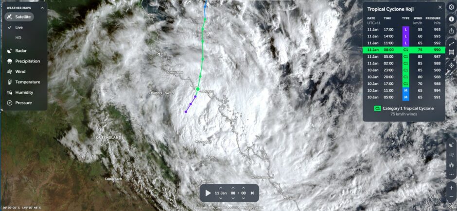
Tropical Cyclone Koji (NE Queensland)
While this was occurring, Tropical Cyclone Koji made landfall south of Townsville (Queensland). This occurred at the same time the Victorian bushfires were occurring. Fortunately, this was not a strong system and the maximum known winds recorded occurred at:
- Willis Island where a single gust topped 133 km/h.
- Hamilton Island where one gust reached 117 km/h.
- Flinders Reef 89 km/h.
It can be worked out that the storm reached Category 1 on the Saffir Simpson Scale and Category 2 on the Australian Tropical Cyclone Intensity Scale. It should be noted that the storm weakened prior to final landfall.
As usual with these systems substantial rainfall occurred and flooding ensured. It is known that some affected areas received over 100 and 200 mm of rain including:
- Mackay Airport - 77.2 mm to 9 am on the 11 January and 150.2 mm to 9 am on January 12.
- Mackay Racecourse - 79 mm to 9 am on the 11 January and 141 mm to 9 am on January 12.
I am aware that the storm system after landfall moved towards the west and inland where a town called Clermont received 203.2 mm of rain on the 12 January.
The area around Mackay south to Rockhampton received the heaviest rainfall from the event. It would also appear that the Mackay region received the heaviest weekly rainfall totals between January 10 and January 16 where weekly totals across the region ranged from 265 mm to 623 mm (With Mt Jukes northwest of the city receiving the 623 mm).
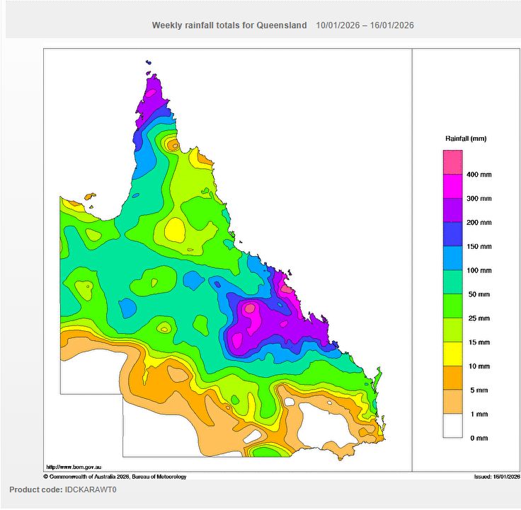
The main impact was the amount of rain that fell. Fortunately, major wind related damage was minimal due to the system weakening prior to landfall.
The above shows how volatile the weather has been across Australia over the past week.
Flying back from Indonesia Wednesday morning, there was evidence of the recent heatwave and fires as a smoke haze could be seen lower down when peering out of the window of the aircraft. The inland regions of NSW had clear skies and there was no evidence of recent rains across the inland of the state. However, thunderstorm clouds were observed as we approached the Great Dividing Range around Mudgee indicating unstable weather not too far west of Sydney at that time.

I have attached an image of Tropical Cyclone Koji using Zoom Earth at landfall near Mackay (Above).