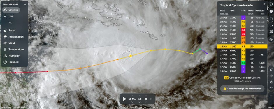
Born south of the Soloman Islands, the storm named as Tropical Cyclone Narelle looks set to become a significant storm system and one that will be remembered for a long time.
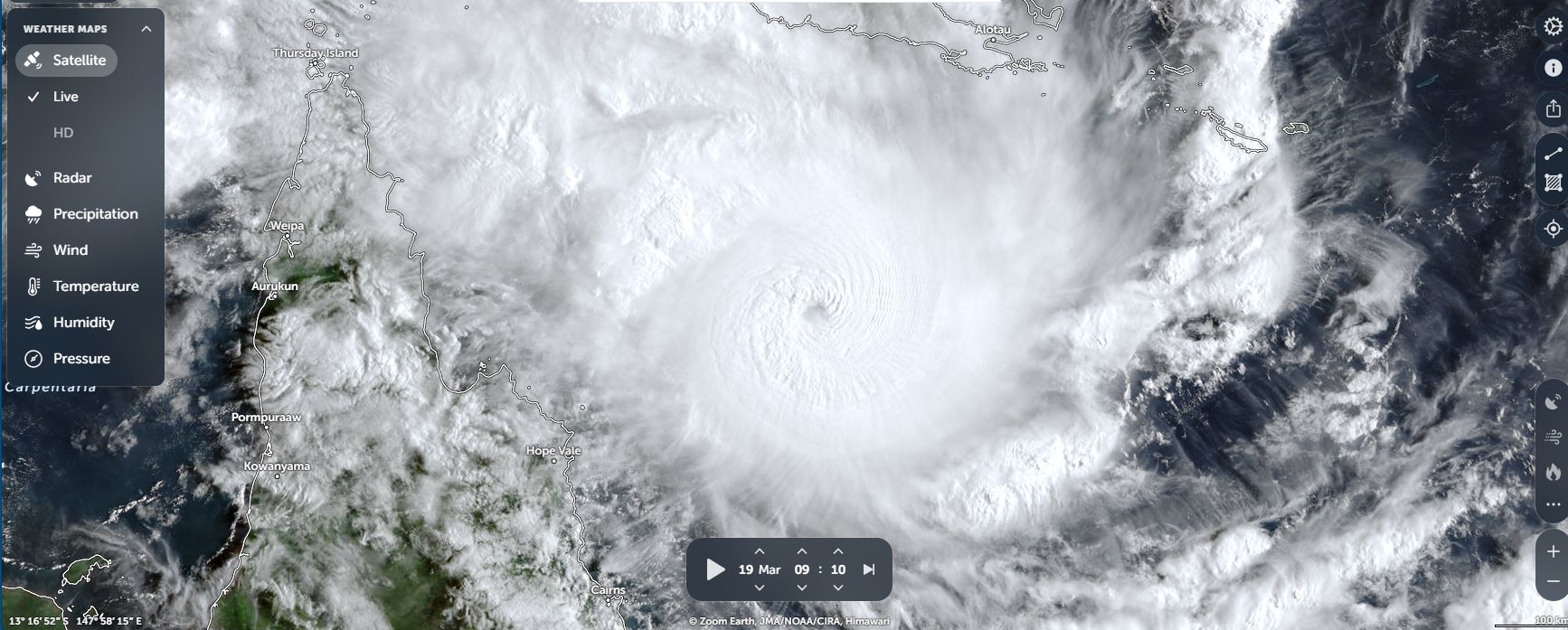
The storm took shape during Tuesday and Wednesday, travelled at considerable speed westward (I heard reports of 18 km/h) then made landfall Friday morning across an isolated area of the north Queensland coastline near Lockhart River.
The storm was fueled by oceanic temperatures heated to at least 29C (Source CIMSS).
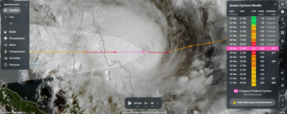
Prior to landfall, the storm appeared to have reached peak strength as a:
- High end Category 4 or a low end Category 5 system under the Australian Tropical Cyclone Intensity Scale 1989.
- A Category 4 system under the Saffir Simpson Scale.
There appears to be some question marks in terms of its peak strength prior to landfall. Notwithstanding the above, the storm is clearly the strongest one this season to impact the Australian coastline.
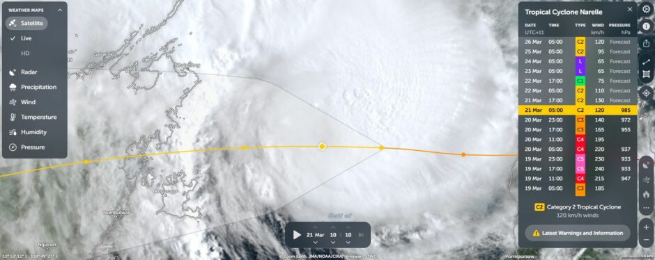
What makes this storm rather interesting is that it appears that after developing within the Coral Sea which is part of the broader Pacific Ocean, the storm has potential to make landfall twice (Second time over the Northern Territory coastline south of Nhulunbuy) then cross the base of the Top End of the Northern Territory then cross the coast again over northern Western Australia, then continue westwards into the Indian Ocean. It is rare to see this occur.
Normally such storms tend to collapse once they cross onto land.
The storm did weaken after it made landfall near Lockhart River but has retained some strength. It crossed back out to sea south of Weipa early Saturday morning. At the time of writing, the storm is passing over waters heated to 30C within the Gulf of Carpentaria and approaching the eastern Northern Territory coastline south of Nhulunbuy as a:
- Category 2 system under the Australian Tropical Cyclone Intensity Scale.
- Category 1 system under the Saffir Simpson Scale.
The storm should make landfall in a remote area, cross the base of the Top End then go back out to sea and then re intensity. The storm may make partial landfall again over the northern Kimberly coastline but remain partially out to sea. According to CIMSS, the storm should continue to track west to west south west into the Indian Ocean. It appears that the storm could re intensify as it moves away from Australia.
This is a very interesting track because it appears that in the longer term:
- The monsoon over Northern Australia should start to weaken as the transition of seasons gather pace. The storm looks set to pull tropical moisture away resulting in the first dry period for a while.
- Further south, contribute to a transition of seasons across southern Australia. In this regard, a strong cooler change is set to sweep through Southern Australia (Thursday and Friday) resulting in much cooler air passing over and pushing out the tropical moisture. Maximum temperatures are set to drop dramatically.
As such, the storm looks set to have a dramatic impact on the weather right across Australia in coming days in terms of starting the transition to Autumn across southern areas and the transition to the dry season for northern areas.
Queensland Landfall
The storm made landfall across an area where weather stations and rain gauges are sparely separated or nonexistent. As such, a true account of peak winds and rainfall does not exist.
Peak wind speeds were estimated at around 195 km/h with peak gusts of up to 270 km/k but this was at a time when the storm was still out to sea.
At Landfall, the weather station at Lockhart River which was located 50 km from the eye experienced a peak wind gust of 115 km/h. The same weather station recorded 108 mm to 9 am Friday morning followed by another 46.4 mm thereafter. Lockhart River was not badly impacted. Other than minor damage and power loss, the township escaped the worst of the storm.
Real data on what occurred is hard to obtain as the storm has avoided a population centre.
The storm has produced flooding rains across the Weipa region including:
- Weipa – 226 mm.
- Fall Creek – 221 mm.
- Werlock River – 200 mm.
This would have contributed to flooding of the area (Figures to 9 am Saturday morning).
A peak wind gust of 109 km/h did occur at Weipa as the system passed over.
It will be interesting to see what occurs as it passes over the base of the northern Territory and areas that have already seen significant flooding such as what recently occurred at Katherine.
The Northern Territory has seen considerable flooding of recent weeks including that of Alice Springs again over the past week, Katherine earlier this month and now this storm system which is threatening more flooding rains.
Still, this is an interesting storm that is noteworthy due to its current behaviour and likely future behaviour in coming days.
I have attached images from Zoom Earth (NASA) showing the path of the storm to date across northern Australia