The continent of Australia is often regarded as having the most varied weather found anywhere in the world. Over the past week and especially during Wednesday, this held true for large areas of the south.
From heat to gales, the contrast of weather across the continent was considerable.
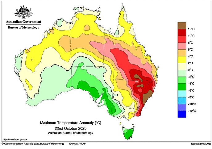
Hot northwest winds were brought down from the desert interior over New South Wales ahead of a cloud mass and associated cold front which resulted in a wide variety of weather extremes depending on location.
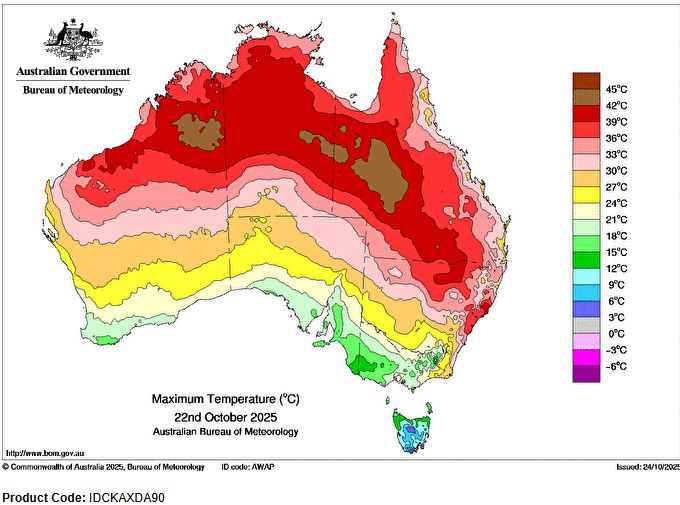
Much of eastern and northern New South Wales experienced a day where maximum temperatures soared to over 30C and for Sydney, maximum daytime temperatures soared to 38C or higher while gale force winds across Victoria and southern areas that exceeded 100 km/h in some areas, brought their own separate issues including two fatalities.
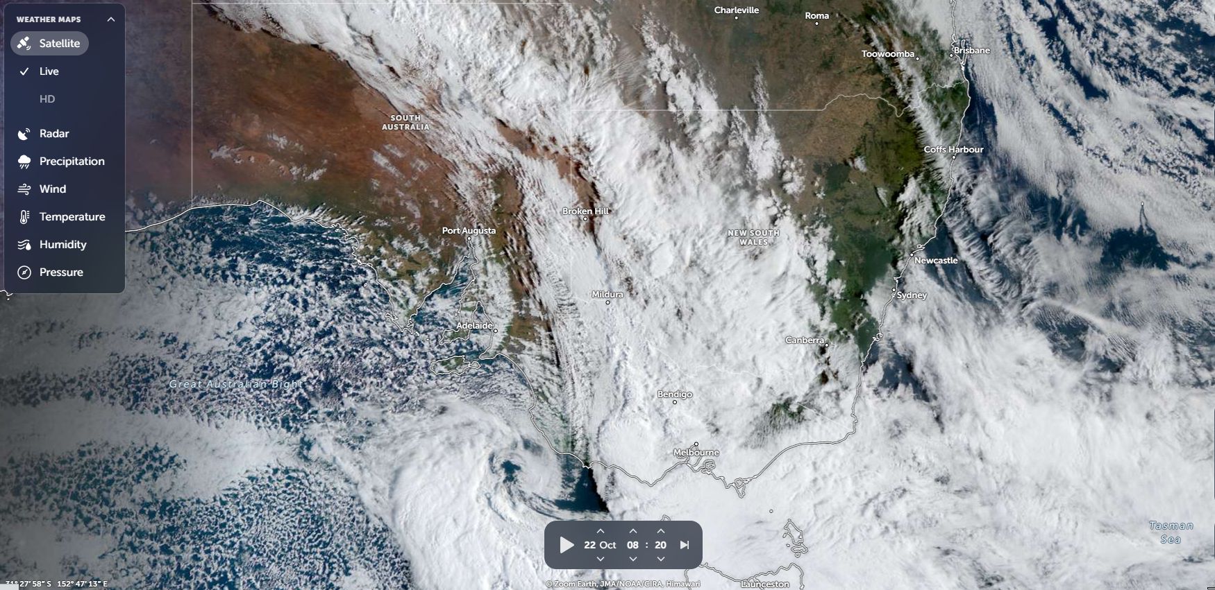
The contrast between the clashes of two air masses over southern Australia is contrasted below.
1 – Heat Eastern and Northern New South Wales during Wednesday
During Wednesday, maximum daytime temperatures soared to 38C and 39C across much of Sydney and at some locations, new daily temperature records were set for the month of October.
For the Sydney basin, there are several instances over the years and decades where maximum daytime temperatures have soared to 38C or higher during October and thus such high temperatures are not unheard of at this time of the year.
For Penrith (Foot of the Blue Mountains) as an example (Records have only existed for 31 years at Penrith Lakes), 37C and 38C days have occurred in October 2004, 2006, 2015 and 2019 and now 2025.
The maximum temperature of October 22 2025 being 39.5C at Penrith Lakes only just exceeded the 38.9C recorded on October 14 2004 and the 39C day that occurred on October 20 this year (2025). It appears that a new maximum temperature record for October now exists at this weather station site.
Maximum daily temperatures for Wednesday 22 October reached:
- Bankstown Airport 39.8C (New October maximum temperature record for maximum temperature at this weather station site).
- Penrith Lakes 39.5C (New temperature record as stated above).
- Sydney Olympic Park 38.8C.
- Horsley Park 38.3C (New October maximum temperature record for this weather station site).
Outside Sydney New South Wales:
- Taree 41.2C.
- Narrabri 39.2C.
Outside Sydney (Other areas)
- 43.3C Julia Creek Airport (South Australia).
- 43.1C Winton Airport (South Australia).
Incredibly it reached 30.4C at Guyra Hospital – The town of Guyra sits 1,300 metres above sea level on the Northern Tablelands of New South Wales making this quite remarkable for such a location.
Even overnight minimum temperatures were exceptional for some locations for the day including:
- Walgett 31.1C.
- Thargomindah Airport 29.6C.
- Brewarrina Hospital 28C.
- Bourke Airport 27.9C.
(All locations across the northwest of the state).
In contrast to this and behind the cool change or under cloud, it reached just 21.6C at Wagga Wagga and 22.6C at Albury Airport across the southern areas of the state behind the wind change.
2 – Cold front and low pressure cell – Gale force winds impact southern areas.
Across Victoria, strong to gale force winds associated with a cold front and low pressure area generated another set of issues.
The strongest verified winds from this event includes:
- Wilsons Promontory Lighthouse (Southern Victoria) – 130 km/h.
- Mt Gellibrand (Victoria) – 120 km/h.
- Montague Island (South Coast of New South Wales) – 111 km/h.
- Nerriga (Southwest of Nowra) – 102 km/h.
- Robe Airfield (South Australia) – 94 km/h.
- Stawell Aerodrome (Wimmera of Victoria) – 91 km/h.
It is known that trees were brought down especially across Melbourne and power loss resulted in some areas. Unfortunately, during the event, there were two fatalities.
The weather system brought some rainfall across the state but nothing too significant.
3 – Rain (South Australia)
The weather system brought useful rainfall to parts of drought stricken South Australia’s southeast with 25 to 45 mm of rain falling including:
- Williamstown (Adelaide South Australia) – 45 mm.
- Mount Crawford AWS (Adelaide/ Lofty) – 39.6 mm.
- Hamley Bridge – 36.6 mm.
- Steingarten Vineyard – 36 mm.
- Cromer Road (Mt Loft Ranges) – 34.8 mm.
These are useful falls going into Summer. The best falls occurred within the southern and southeastern areas of South Australia with lighter totals spreading further east. The rainfall failed to reach the east coast of the continent.
The satellite photo of southern Australia for Wednesday 22 October shows an extensive cloud mass over southern areas splitting the southern areas and northern areas into two halves each with contrasting weather (Feature Image). Interestingly, the cloud mass broke apart as it approached the coast so only scattered cloud reached the coast with no rainfall during the late afternoon and evening. For Sydney, this was a dry change following the hot day with no rainfall occurring.